
Much of East Croydon’s history is recorded in its street names (see below). East Croydon Community Organisation have submitted information we have gathered so far to the London Street Guide project. This is far from complete and we would be grateful, in particular, for any information about the origins of the names of Alpha Road, Bisenden Road, Edwin Place, Jackson’s Lane and John’s Terrace.
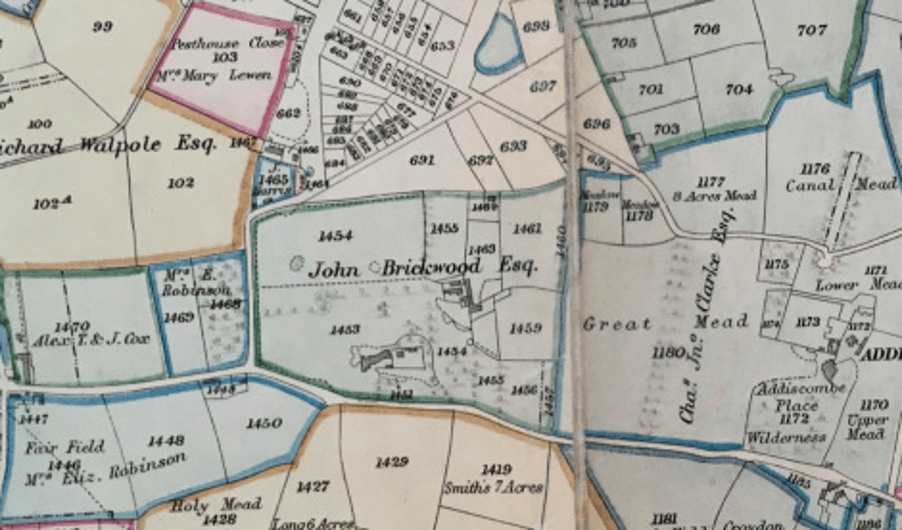
In compiling the information, we were greatly assisted by Brendan O’Connor, Carole Roberts, Croydon Museum & Archives Service, David Morgan, Jerry Fitzpatrick, Scott Hatton and Sophie Rahman. The image is a detail of the Croydon enclosure map of 1801, a copy of which can be found in the Croydon Museum & Archive in Croydon Clocktower.
Further information about the history of East Croydon can be found on these pages, in approximately chronological order
- The Heron family of 16th century Addiscombe part 1
- The Heron family of 16th century Addiscombe part 2
- John Brickwood, owner of Brickwood House 1790s to 1822
- The Croydon Enclosure 1796- 1801 (as it affected East Croydon)
- East Croydon’s connection to the Trans-Atlantic Trade in Enslaved People
- Croydon Minster window commemorating John Blake, owner of Brickwood House 1822-1852
- Sir Benjamin Hallowell, tenant of Brickwood House 1822-1828
- The Glamorgan, East Croydon & India Pale Ale
- Hall & Co Croydon Ltd, Cherry Orchard Road 1839 – 1975
- Croydon Walnut Fair at the Fair Field, George Street
- Mid-19th century gravel pits and brickfields in East Croydon
- A short history of Oval schools 1873-1973
- Oval Road School teacher & family lost at sea on way to a new life in Australia, 20 January 1886
- Danger of death: electricity substations in and around east Croydon 1896 to present
- Caryl Brahms, writer, born at 28 Morland Road in 1901
- Croydon Skating Rink, Cherry Orchard Road 1909-1915
- The East Croydon fallen from World War One
- Two Trinidadian World War One soldiers who lived in Amberly Grove, off Morland Road
- Charles Davey, cycling champion, owner of a bicycle & gramophone shop on Lower Addiscombe Road from 1925
- Stan Bult, recorder of clowns’ faces on eggs, lived at 26 Canning Road from the 1930s to 1966
- Elizabeth Haffenden of Hazeldean Road, costume designer for the movies 1933 – 1976
- Croydon International Language Club, East Croydon 1938-1966
- Sir Philip Game Centre Youth Club, Morland Avenue, established 1946
- Wizz Jones, guitarist, Oval Road 1950s
- One Croydon built on Addiscombe Road 1968-9

Addiscombe Court Road
Thomas Benjamin Muggeridge lived in a house called Addiscombe Court in 1872. This was on Upper Addiscombe Road (as Addiscombe Road was then known), between the corner of a lane into a field and the premises of W. Flower, a beer retailer (later The Cricketers). The Muggeridge family had lived in a house on the site since as early as 1855, when it was headed by Edward, a corn merchant. Addiscombe Court Road was built following the line of the lane and houses are listed on it for the first time in 1906.
Addiscombe Road
First appeared on a map of 1594, connecting the town of Croydon with the hamlet of Addiscombe to the east (on the corner of today’s Sandilands). Known as Upper Addiscombe Road in the 19th century, it lay along a spring line, the water running downslope to the north in the direction of Lower Addiscombe Road.
Alpha Road
The land on the corner of Cross Road and Lower Addiscombe Road was the last part of the Leslie Lodge estate to be sold, in 1896, allowing Alpha Road to be built (see Leslie Park Road and Leslie Grove). The house itself was demolished c1900. It is not known why it was given this name. However, the name was commonly used at the time to refer to the first street built in a new development.
Alpha Place
A short road with just two dwellings, off Leslie Park Road. First noted on a sales particular of 1903 that also list the sale of nos. 18 to 46 Alpha Road. As with the latter, it is not known why it was given this name.
Billinton Hill
A short road leading upwards to East Croydon station from Cherry Orchard Road. Variously referred to as Station Approach, Yard or Street in street and telephone directories. Renamed in the late 1990s, after the station was redeveloped, possibly after Robert Billinton, the Locomotive Engineer of the London, Brighton and South Coast Railway from 1890 to 1904 or his son, Lawson Boskovsky Billinton, who later held the same position from 1912 to 1923.
Bisenden Road
Bisenden Road may be named after Thomas Bisenden, the son of a butcher from Croydon, who died in 1776. Some of the land he inherited lay between today’s Chisholm & Lebanon Roads. Thomas sold this land to an Edward Coulsdon, who later sold it on to John Brickwood.
Blake Road
Probably named after John Blake, an auctioneer who lived at 65 Park Lane. He had bought the Brickwood estate after the death of John Brickwood in 1829 (see Brickwood Road). However, he did not occupy it, letting it to a series of tenants. John Blake was a member of the Croydon Improvement Board. Despite a cholera epidemic in 1831-32, the Board had dragged its heels in making actual improvements. In 1837, Croydon was the unhealthiest registration district in Surrey. Half the 1550 houses in Croydon were not supplied with water. Small pox, fever and diarrhoea were rife. After another cholera epidemic in 1848, the government responded by passing the Public Health Act. Elections for the Croydon Board of Health took place the following year. John Blake topped the poll with 1002 votes and Robert Wells Elyes, his tenant at Brickwood House, was also elected. The Croydon Board of Health was the first in the country to complete a combined drainage, sewage and water supply system. By 1852 nearly 2000 houses had been connected. John Blake died that year at the age of 72, the second oldest person in the parish of Croydon at that time.
Brickwood Road
Named after John Brickwood, a merchant and banker, who built Brickwood House nearby at the end of the 18th century. He already owned considerable land in the parish of Croydon and was one of the local landowners who had petitioned parliament in 1796 for leave to introduce a private bill to enclose common land in the parish of Croydon. The poor of Croydon protested at the loss of their right to grazing their livestock and gather firewood without success. After the enclosure bill was enacted, John Brickwood bought further land both on nearby Croydon Common and on Norwood Common. In East Croydon, he owned all the land east of Cherry Orchard Road, as well as a few plots on the west side near the junction of Moreland Road. Much of the land was sold when his company became bankrupt in 1810. However, Brickwood bought back Brickwood House and the grounds between Cedar Road and Addiscombe Road the following year at auction for £7500. It was sold after his death in 1822 to the John Blake, a local surveyor (see Blake Road). The house was demolished in 1908 and its land divided into the streets we know today.
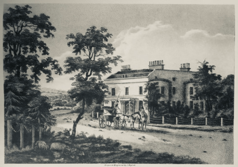
Brickwood House 1805
Bridge Row
A short row of house off the north end of Cross Road, on a patch of land isolated when the railway line was built to the west. Probably got its name from lying just to the south of Windmill Bridge.
Cart Lodge Mews
A short private road off Lebanon Road. A 1903 sales particular notes a brick-built stabling in this area, complete with a timber-built Cart Lodge, cemented yard, WC and manure pit.
Cedar Road
Laid out along the line of the boundary of the grounds of Brickwood House from 1852 -1908 (see Brickwood Road and Oval Road). The house was said to be “enclosed in a park tastefully planted with forest and other trees”. Given the junction with Lebanon Road to the east, it seems likely that these grounds included a Cedar of Lebanon tree.
Cherry Orchard Road
Can be seen on maps from at least 1729. Originally called Coney Lane up to the junction to the track over the common, later known as Cross Road. North of this junction, it was a private carriage way called Lee’s Road. To the south of this junction, the enclosure map of 1801 shows an orchard on its western side extending to (Upper) Addiscombe Road, owned by a Mrs E Robinson. It was an orchard full of cherry trees. When the cherries were ripe, a cherry fair was celebrated on the spot. By 1851, the road was called Cherry Orchard Road along its full extent. By then the orchard was long gone. The land had been bought by the London and Brighton Railway company, which began running trains from London Bridge to the coast via East Croydon in 1841.
Chisholm Road
Chisholm Road took its name from James Chisholm, the last resident of Addiscombe Lodge who lived there from about 1891 to 1902. James had been born in Edinburgh on 5 April 1846. His wife, Rosina, had been born in the West Indies and gave birth to their daughter Gertrude in 1869 in Barbados. On the 1881 census, James is listed as an assistant actuary, living with his wife in a modest villa on Nicholson Road, Addiscombe. Ten years later, he was living Addiscombe Lodge, off Addiscombe Road, a grand house with five servants, a drive, substantial grounds and several outbuildings, including a gardener’s lodge. James died in Banff, Alberta, Canada in 1914. By then Chisholm Road had been driven through his former home and lined with houses.
Colson Road
May be named after Edward Colson, baptized in 1736, listed as paying poor rates in 1779 and buried 1793 in Croydon parish church. An Edward Coulsdon had bought land from Thomas Bisenden that currently lies between Chisholm and Lebanon Roads. By 1791, he had sold this land to John Brickwood. Brickwood later left bequests to an Edward Coulson and a Henry Colson in his will.
Cross Rd
Shown as a path across Croydon Common on a map dated to 1768. The common reached from Broad Green to Selhurst (west to east), White Horse Road to Cherry Orchard Road (north to south). There were gates at the ends of these paths to stop the animals grazing on the common from straying onto the highway. The path from the Broad Green Gate to Selhurst Gate branched off along what is now St James Road/Lower Addiscombe Road. Cross Road developed from a track branching off this, leading to Coney Lane Gate at its junction with Cherry Orchard Road. It was named after James Cross, an early landlord of the Windmill public house. From at least 1859, its small side roads are also listed in street directories. Some of these survive today as unadopted roads (Edwin Place, Jackson’s Place, John’s Terrace).
Edwin Place
Unadopted road off Cross Road. Appears in the 1859 street directory, but it is not known why it was given this name.
Heron Road
Named after the wealthy, well connected Heron family, who owned an estate that included land to the north of Addiscombe Lane roughly from Canning Road to Ashburton Road in the 16th century (though not the land on which Heron Road lies). They also owned the Croydon rectory and, as such, were entitled to be buried in Croydon 14th century parish church. Several items relating to the family survived the fire that destroyed this building in 1866 and can be found in the present parish church, including
- Two shields (on the north wall) and a brass of seven daughters (on the south wall) from the memorial to Thomas Heron, who died 1544, and his wife Elizabeth.
- A brass plate of William Heron, who died in 1563, and his wife Alice in the north chancel wall
- three stone shields from the tomb of Sir Nicholas Heron, who died in 1566 at the west end of the church
By the 17th century, the estate no longer belonged to the family.
Jackson’s Lane
Unadopted road off Cross Road. Appears in the 1859 street directory, but it is not known why it was given this name.
John’s Terrace
Unadopted road off Cross Road. Appears in the 1859 street directory, but it is not known why it was given this name.
Lebanon Road
Laid out along the line of the former boundary of the grounds of Brickwood House in 1810 (see Brickwood Road). The house was said to be”enclosed in a park tastefully planted with forest and other trees”. Given the junction with Cedar Road to the west, it seems likely that these grounds included a Cedar of Lebanon tree.
Leslie Grove
The Leslie Lodge estate west of Cherry Orchard Road was sold piecemeal (see Leslie Park Road). The land fronting Lower Addiscombe Road sold in the 1850s and developed into shops. The land at the rear was sold in 1874 to a buyer who drove a road through it to enable a profitable building scheme, thus creating Leslie Grove.
Leslie Park Road
Laid along part of the southern boundary of the Leslie Lodge estate. Leslie Lodge had been built c1825 on what was then known as Addiscombe Road, but what is now 22-24 Lower Addiscombe Road. The earliest owners are unknown and it is not clear whether they bore the name Leslie. The pub sign of the former Leslie Arms nearby displays the coat of arms the Lords of Rothes, whose clan name is Leslie, together with the family motto “Grip Fast”. The clan was founded in 1070 AD, when Bartholomew, a Hungarian nobleman attached to the fugitive Saxon court, married Beatrix, the sister of Malcolm III of Scotland. They were granted lands at Leslie in the district of the Garioch, near Aberdeen, from which they took their name. The family had links with West Surrey from 1772, when Lady Jane Elizabeth Leslie, the Countess of Rothes, married Sir Lucas Pepys, the physician to George III, who lived in Juniper Hall, near Leatherhead. However, there are no known links between the Leslie family and Croydon.
The 1844 tithe map shows the Leslie Lodge estate covered much of the land between Cross Road and Leslie Park Road, as well as land to the north of what is now Lower Addiscombe Road. By 1851, it was owned by Mary Vandervell, who put that part of it to the east of Cherry Orchard Road onto the market. The sales particulars noted that Leslie Park Road had already been laid through the land making it “a first class site for the erection of suburban residences”. It had been cut through and gravelled by Hall & Co for £162. Within ten years, the entire frontage along northern Leslie Park Road had been developed.
Leslie Place
Leslie Place is a short road off the south side of Leslie Grove that provides access to the rear of some of the buildings on Cherry Orchard Road. It would have been created sometime between 1874 and 1894 (when it appears on an Ordnance Survey Map). For the origin of the name, see Leslie Park Road.
Lower Addiscombe Road
First appears as a path across Croydon Common on a map dating to 1768. In 1801, it was referred to as a public carriage and was called Addiscombe Road, then St James Road, probably from 1829 when St James Church was built to the west. In street directories from 1865 it was referred to as St James Rd East and finally as Lower Addiscombe Road from 1869.
Oval Road
This was once a gravel pit, the gravel being used for road building. In 1852, part of the former Brickwood estate came onto the market and Oval Road was laid out. The construction of Leslie Park Road enabled it to be a through road. No plots were offered for sale on the Oval itself, which was to be a pleasure garden for the general recreation of the plot owners, who were given rights of way over it in perpetuity. 16 years later, they relinquished their rights and the Oval was sold for housing development.
Tunstall Road
Named after the Tunstall family who owned Addiscombe Place from 1624. Sir John Tunstall, was a gentleman usher to Queen Anne 1, the consort of King James. His son Henry was a gentleman usher to Henrietta Maria, wife of Charles 1. During the civil war, parliament organized committee to regulate those parts of the country that were under its sway. The Surrey Committee generally sat in Kingston, but sometimes in Croydon, including at The Greyhound. They raised money by a rate upon the value of lands and goods, with assessments made by local people. In 1644, Henry Tunstall was the treasurer to whom the payments were made at The Greyhound. Neither Henry or his father were likely to have been parliamentarians, but if they had willingly aided the royal cause, they could have had their estates confiscated. In 1646, Henry was ordered to account for a large amount of money, which he could not do and was arrested. The Tunstalls were deep in debt and had to sell the Addiscombe estate (to Purbeck Temple). Henry died in 1650, his father in 1651 and his mother, Penelope, a year later.
The land on which Tunstall Road lies lay outside the Addiscombe Estate. It was used for agriculture until the road was laid out in the early 20th century. Houses are listed on Tunstall Road for the first time in the 1907 Croydon street directory.
Bibliography
- Anon. 1852. “Attribute to the memory of the Late John Blake” from the Surrey Standard, 28 February 1852
- Anon. Not dated. Notes from the reproduction of a print of Brickwood House 1805 by John Hassell. Canning & Clyde Residents Association & Friends. 2002. The Book of Addiscombe vol 2. Halsgrove.
- Brian Lancaster 2001 “The Croydon Case” Dirty Old Town to Model Town. The Making of the Croydon Board of Health and the Croydon typhoid epidemic of 1852-3. Croydon Natural History & Scientific Society
- Bisenden family wills 1762-1783 AR366 , Croydon Archives.
- Chisholm family https://bergergirls.com/familygroup.php?familyID=F81480&tree=Strausstown&sitever=standard
- Colson records at St John’s Croydon (accessed on findmypast website 30 August 2023)
- Corbett Anderson, J. 1889. Croydon Enclosure 1787-1801. Croydon
- Cracroft’s Peerage website http://www.cracroftspeerage.co.uk
- Croydon Parish Poor Rates 1779 (PR1/1/12/19) Croydon Archives
- Ducarel, Dr A.C. 1783. Account of the Town, Church, and Archepiscopal Palace of Croydon in the county of Surrey from its foundation to 1783. Society of Antiquaries.
- Garrow, Rev. D.W. 1818. The History and Antiquities of Croydon. W.Annan.
- Geni website https://www.geni.com/surnames/leslie
- Gent, J. 2002. Croydon Past. 2002. Philimore & Co Ltd.
- London Brighton and South Coast Railway website http://www.lbscr.org/History/People/Locomotive-Engineers.xhtml#R.J.Billinton
- Malden, H.E. 1911. The Victoria County History of the County of Surrey, vol. 3. Constable.
- Marshall & Downey Index p13 6.7.1866 Admissions of Mary Ann Lambert reciting death of Thomas Berrington Croydon Archives
- Paget, C.G. 1937. Croydon Homes of the Past. Croydon Central Library.
- Paget notebook 15 pages 273–274 of notebook 15: Common Pleas – Recovery Roll – 832/81, Croydon Archives
- Stewart, F.D. 1982. Croydon History in Field & Street Names. AMDC Publishers Ltd
