
East Croydon Community Organisation have submitted information about the street names in our area to the London Street Guide project. This is far from complete and we would be grateful, in particular, for any information about the origins of the names of Alpha Road, Bisenden Road. Edwin Place, Jackson’s Lane and John’s Terrace.
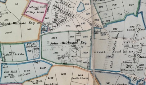
In compiling the information, we were greatly assisted by Brendan O’Connor, Carole Roberts, Croydon Museum & Archives Service, David Morgan, Jerry Fitzpatrick and Sophie Rahman. The image is a detail of the Croydon enclosure map of 1801, a copy of which can be found in the Croydon Museum & Archive in Croydon Clocktower.
Addiscombe Court Road
Thomas Benjamin Muggeridge lived in a house called Addiscombe Court in 1872. This was on Upper Addiscombe Road (as Addiscombe Road was then known), between the corner of a lane into a field and the premises of W. Flower, a beer retailer (later The Cricketers). The Muggeridge family had lived in a house on the site since as early as 1855, when it was headed by Edward, a corn merchant. Addiscombe Court Road was built following the line of the lane and houses are listed on it for the first time in 1906.
Addiscombe Road
First appeared on a map of 1594, connecting the town of Croydon with the hamlet of Addiscombe to the east (on the corner of today’s Sandilands). Known as Upper Addiscombe Road in the 19th century, it lay along a spring line, the water running downslope to the north in the direction of Lower Addiscombe Road.
Alpha Road
The land on the corner of Cross Road and Lower Addiscombe Road was the last part of the Leslie Lodge estate to be sold, in 1896, allowing Alpha Road to be built. The house itself was demolished c1900. It is not known why it was given this name.
Alpha Place
A short road with just two dwellings, off Leslie Park Road. First noted on a sales particular of 1903 that also list the sale of nos. 18 to 46 Alpha Road. As with the latter, it is not known why it was given this name.
Billinton Hill
A short road leading upwards to East Croydon station from Cherry Orchard Road. Variously referred to as Station Approach, Yard or Street in street and telephone directories. Renamed in the late 1990s, after the station was redeveloped, possibly after Robert Billinton, the Locomotive Engineer of the London, Brighton and South Coast Railway from 1890 to 1904 or his son, Lawson Boskovsky Billinton, who later held the same position from 1912 to 1923.
Bisenden Road
The Croydon Museum and Archives Service holds the wills of the Bisenden family 1762-1783. However, these are too fragile to be scanned and are not currently accessible due to the pandemic. The connection of this family to Bisenden Road is not currently known.
Blake Road
Probably named after John Blake, an auctioneer who lived at 65 Park Lane and died in 1852. He had bought the Brickwood estate after the death of John Brickwood in 1829. (see Brickwood Road). However, he did did not occupy it, letting it to a series of tenants including, from 1823-28, Sir Benjamin Hallowell, a Commander in the Royal Navy who had served with Nelson. He died at the age of 72, the second oldest person in the parish of Croydon at that time.
Brickwood Road
Named after Brickwood House, built at the end of the 18th century by John Brickwood, a merchant and banker. He owned considerable land in the parish of Croydon and was one of the local landowners who petitioned parliament in 1796 for leave to introduce a private bill to enclose common land in the parish of Croydon. The poor of Croydon protested at the loss of their right to grazing their livestock and gather firewood without success. After the enclosure bill was enacted, John Brickwood bought further land both on nearby Croydon Common and on Norwood Common. In East Croydon, he owned all the land east of Cherry Orchard Road, as well as a few plots on the west side near the junction of Moreland Road. Much of the land was sold when he became bankrupt in 1810. However, Brickwood bought back Brickwood House and the grounds between Cedar Road and Addiscombe Road the following year at auction for £7500. It was sold after his death in 1822 to the John Blake, a local surveyor (see Blake Road). The house was demolished in 1908 and its land divided into the streets we know today, including Brickwood Road.
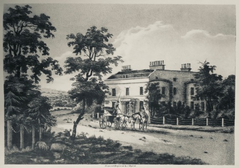
Brickwood House 1805
Bridge Row
A short row of house off the north end of Cross Road, on a patch of land isolated when the railway line was built to the west. Probably got its name from lying just to the south of Windmill Bridge.
Cart Lodge Mews
A short private road off Lebanon Road. A 1903 sales particular notes a brick-built stabling in this area, complete with a timber-built Cart Lodge, cemented yard, WC and manure pit.
Cedar Road
Laid out along the line of the boundary of the grounds of Brickwood House from 1852 -1908 (see Brickwood Road and Oval Road). The house was said to be”enclosed in a park tastefully planted with forest and other trees”. Given the junction with Lebanon Road to the east, it seems likely that these grounds included a Cedar of Lebanon tree.
Cherry Orchard Road
Can be seen on maps from at least 1729. Originally called Coney Lane up to the junction to the track over the common, later known as Cross Road. North of this junction, it was a private carriage way called Lee’s Road. To the south of this junction, the enclosure map of 1801 shows an orchard on its western side extending to (Upper) Addiscombe Road, owned by a Mrs E Robinson. It was an orchard full of cherry trees. When the cherries were ripe, a cherry fair was celebrated on the spot. By 1851, the road was called Cherry Orchard Road along its full extent. By then the orchard was long gone. The land had been bought by the London and Brighton Railway company, which began running trains from London Bridge to the coast via East Croydon in 1841.
Chisholm Road
Said to take its name from James Chisholm, the last resident of Addiscombe Lodge. This large house and its grounds can be seen on the Croydon tithe map of 1844 as occupying the land on which the road lies, formerly part of the Brickwood estate. It was already fully built up by 1911, when it appear on an Ordnance Survey map.
Colson Road
Possibly named after Thomas Colson, a surveyor, listed as living nearby on Croydon Common in the 1849 street directory.
Cross Rd
Shown as a path across Croydon Common on a map dated to 1768. The common reached from Broad Green to Selhurst (west to east), White Horse Road to Cherry Orchard Road (north to south). There were gates at the ends of these paths to stop the animals grazing on the common from straying onto the highway. The path from the Broad Green Gate to Selhurst Gate branched off along what is now St James Road/Lower Addiscombe Road. Cross Road developed from a track branching off this, leading to Coney Lane Gate at its junction with Cherry Orchard Road. It was named after James Cross, an early landlord of the Windmill public house. From at least 1859, its small side roads are also listed in street directories. Some of these survive today as unadopted roads (Edwin Place, Jackson’s Place, John’s Terrace).
Edwin Place
Unadopted road off Cross Road. Appears in the 1859 street directory, but it is not known why it was given this name.
Heron Road
Named after the wealthy, well connected Heron family, who owned an estate that included land to the north of Addiscombe Lane roughly from Canning Road to Ashburton Road in the 16th century (though not the land on which Heron Road lies). They also owned the Croydon rectory and, as such, were entitled to be buried in Croydon 14th century parish church. Several items relating to the family survived the fire that destroyed this building in 1866 and can be found in the present parish church, including
- Two shields (on the north wall) and a brass of seven daughters (on the south wall) from the memorial to Thomas Heron, who died 1544, and his wife Elizabeth.
- A brass plate of William Heron, who died in 1563, and his wife Alice in the north chancel wall
- three stone shields from the tomb of Sir Nicholas Heron, who died in 1566 at the west end of the church
By the 17th century, the estate no longer belonged to the family.
Jackson’s Lane
Unadopted road off Cross Road. Appears in the 1859 street directory, but it is not known why it was given this name.
John’s Terrace
Unadopted road off Cross Road. Appears in the 1859 street directory, but it is not known why it was given this name.
Lebanon Road
Laid out along the line of the former boundary of the grounds of Brickwood House in 1810 (see Brickwood Road). The house was said to be”enclosed in a park tastefully planted with forest and other trees”. Given the junction with Cedar Road to the west, it seems likely that these grounds included a Cedar of Lebanon tree.
Leslie Grove
The Leslie Lodge estate west of Cherry Orchard Road was sold piecemeal (see Leslie Park Road). The land fronting Lower Addiscombe Road sold in the 1850s and developed into shops. The land at the rear was sold in 1874 to a buyer who drove a road through it to enable a profitable building scheme, thus creating Leslie Grove.
Leslie Park Road
Laid along part of the southern boundary of the Leslie Lodge estate. Leslie Lodge was built c1825 on what was then Addiscombe Road, but what is now 22-24 Lower Addiscombe Road. The earliest owners are unknown and it is not clear whether they bore the name Leslie. The pub sign of the former Leslie Arms nearby displays the coat of arms the Lords of Rothes, whose clan name is Leslie, together with the family motto “Grip Fast”. The clan was founded in 1070 AD, when Bartholomew, a Hungarian nobleman attached to the fugitive Saxon court, married Beatrix, the sister of Malcolm III of Scotland. They were granted lands at Leslie in the district of the Garioch, near Aberdeen, from which they took their name. The family had links with West Surrey from 1772, when Lady Jane Elizabeth Leslie, the Countess of Rothes, married Sir Lucas Pepys, the physician to George III, who lived in Juniper Hall, near Leatherhead. However, there are no known links between the Leslie family and Croydon.
The 1844 tithe map shows the Leslie Lodge estate covered much of the land between Cross Road and Leslie Park Road, as well as land to the north of what is now Lower Addiscombe Road. By 1851, it was owned by Mary Vandervell, who put that part of it to the east of Cherry Orchard Road onto the market. The sales particulars noted that Leslie Park Road had already been laid through the land making it “a first class site for the erection of suburban residences”. Within ten years, the entire frontage along northern Leslie Park Road had been developed.
Leslie Place
Leslie Place is a short road off the south side of Leslie Grove that provides access to the rear of some of the buildings on Cherry Orchard Road. It would have been created sometime between 1874 and 1894 (when it appears on an Ordnance Survey Map). For the origin of the name, see Leslie Park Road.
Lower Addiscombe Road
First appears as a path across Croydon Common on a map dating to 1768. In 1801, it was referred to as a public carriage and was called Addiscombe Road, then St James Road, probably from 1829 when St James Church was built to the west. In street directories from 1865 it was referred to as St James Rd East and finally as Lower Addiscombe Road from 1869.
Oval Road
This was once a gravel pit, the gravel being used for road building. In 1852, part of the Brickwood estate came onto the market and Oval Road was laid out. The construction of Leslie Park Road enabled it to be a through road. No plots were offered for sale on the Oval itself, which was to be a pleasure garden for the general recreation of the plot owners, who were given rights of way over it in perpetuity. 16 years later, they relinquished their rights and the Oval was sold for housing development.
Tunstall Road
Named after the Tunstall family who owned the former Heron estate from 1624. Sir John Tunstall, was a gentleman usher to Queen Anne 1, the consort of King James. His son Henry was a gentleman usher to Henrietta Maria, wife of Charles 1. Both father and son became deeply in debt during the civil war, probably because they were royalists. They had to sell the house in 1650. The land was used for agriculture until the road was laid out in the early 20th century. Houses are listed on Tunstall Road for the first time in the 1907 Croydon street directory.
Bibliography
Anon. 1852. “Attribute to the memory of the Late John Blake” from the Surrey Standard, 28 February 1852
Anon. Not dated. Notes from the reproduction of a print of Brickwood House 1805 by John Hassell.
Canning & Clyde Residents Association & Friends. 2002. The Book of Addiscombe vol 2. Halsgrove.
Cracroft’s Peerage website http://www.cracroftspeerage.co.uk
Corbett Anderson, J. 1889. Croydon Enclosure 1787-1801. Croydon
Ducarel, Dr A.C. 1783. Account of the Town, Church, and Archepiscopal Palace of Croydon in the county of Surrey from its foundation to 1783. Society of Antiquaries.
Garrow, Rev. D.W. 1818. The History and Antiquities of Croydon. W.Annan.
Geni website https://www.geni.com/surnames/leslie
Gent, J. 2002. Croydon Past. 2002. Philimore & Co Ltd.
London Brighton and South Coast Railway website http://www.lbscr.org/History/People/Locomotive-Engineers.xhtml#R.J.Billinton
Malden, H.E. 1911. The Victoria County History of the County of Surrey, vol. 3. Constable.
Paget, C.G. 1937. Croydon Homes of the Past. Croydon Central Library.
Stewart, F.D. 1982. Croydon History in Field & Street Names. AMDC Publishers Ltd

Dear Angela
Thank you – a very interesting and informative piece.
But ….
Stated in a text to which I was introduced as a child is that the days of our life are three score years and ten – or if by reason of strength four score years.
And from a lovely 19th century American song I learnt that my grandfather had had a clock which was in working order in complete concurrence with the old man’s life – 90 years! So our Grandpa of legend would have been born in the 18th century. This was unusual longevity but not as rare as a truth uttered by Donald Trump.
We are all aware that life expectancy was much lower in early Victorian England. Even giving great weight to that, the parishioners of Croydon must collectively have had exceptionally weak constitutions if the second oldest resident was 72.
Whatever is the source? Has it been carefully fact-checked?
I am just about prepared to believe that the second oldest man on the electoral register was 72, especially if the number of electors on the roll was very low.
Yours with great scepticism!
Jerry xxx
>
LikeLike
That’s what it says in this article Anon. 1852. “Attribute to the memory of the Late John Blake” from the Surrey Standard, 28 February 1852, a copy of which is in Croydon Archives. The average age at death round about that time in Croydon was 35!
LikeLike
I’m using the information from this excellent page as part of our theundergroundmap project. Just for info, as we have dealt with other “Alpha Road”s and the name was generally used to refer to the first street built in a development. This was in the days before the post office asked Londoners (and Croydoners) to rename many of their streets to stop all the repetition of Albert Street, Victoria Street, Alpha Road and the like. (This one stayed unrenamed obviously!)
LikeLike
Thank you, Scott – that’s really helpful.
LikeLike
It’s worth checking out David Morgan’s articles for inside Croydon. He has started looking into street names too.
LikeLike