

- The people behind the initiative
- Background
- A local’s view of the Leslie Arms Junction
- Photographs of the Leslie Arms Junction
- The Community Vision
- Possible design solutions for a new junction
- Mood Board
- Next Steps
The people behind the initiative
The Leslie Arms Junction Area Regeneration group (LAJAR) is a collection of interested people living close to the Leslie Arms junction. We have come together to try and bring about much needed improvements to the ever-deteriorating junction that sits on our doorstep. Our aim is to develop it into somewhere that people can safely use as a local hub, as well as an important transport junction.
LAJAR looks to work with and get the buy-in of the communities from all around the junction as well as the local community groups who work to represent them.
The main strength of the LAJAR group is enthusiasm and local knowledge. However, our members include people we with experience in transport, project management, architecture, and the law, as well as present and past Croydon Councillors.
We hope to get interest in this from the highest levels within Croydon Council and local MPs so that funding can be secured to make the much needed improvements.
Have your say on the regeneration ideas for Leslie Arms Junction by emailing us at mail@eastcroydon.org.uk Please start the title with “LAJAR”
Background
This vision to regenerate the area around the Leslie Arms Junction is the product of people in the local community who desperately want a more welcoming and safer place to shop which could become a community hub as well as just a thoroughfare for cars. Crucially, it needs to be easy and safe for use by pedestrians and cyclists as well as allowing smooth flow of road vehicles.
Everyone involved in working to bring this vision together uses the junction on a regular basis either to shop at or to walk through, sometimes taking our kids to school. We all live in the immediate vicinity of the junction or in the surrounding roads. One member’s child was hit by a car here while on the way to school and the rest of us have become involved due to concerns about the continuing deterioration of what we really want to be our community hub.
Our vision has come about through community engagement and the desire to make this happen. It started over social media through the Covid months. There was so much enthusiasm that a community meeting was held on the 22nd February 2022. This was very well attended by locals and their children, community groups, councillors and member of the political parties. The feedback was incredibly positive and momentum in the vision has been growing ever since with the feedback being incorporated in the vision. We now have a growing number of people who are enthusiastic to see something done to improve the deplorable state of the Leslie Arms Junction.

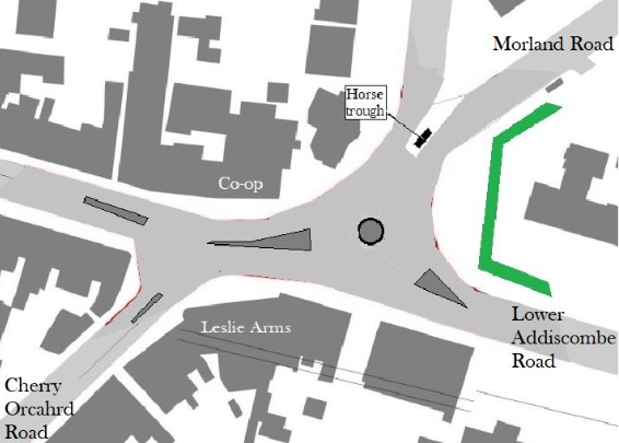
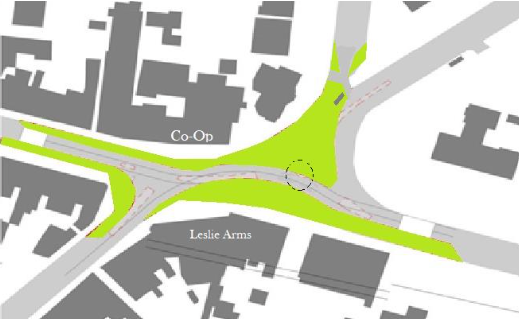
The area that we have focused on is shaded green in the map above. While concentrating on this area we realise that making changes here may affect other roads nearby, the flow of traffic being a main point in question. To get engagement and buy in from the whole community, including that not immediately around the junction, we need to ensure we consider this. It is important that the through flow of traffic using the junction is not diminished and people are not encouraged to use other roads as “rat-runs”. We feel that improvements can be made that will be good for all users and residents.
A local’s view of the Leslie Arms Junction
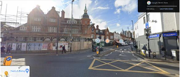
The junction is known by many locals as the Leslie Arms Junction (after the beautiful but dilapidated listed pub on one corner). It is an extremely busy coming together of five roads and one of the main gateways that welcomes people into Croydon. As well as a huge number of cars, pedestrians, cyclists & scooters using the junction, several bus routes that run through it. East Croydon Station is on its doorstep, so it is a busy commuter thoroughfare. Hundreds of parents and kids cross it to get to the seven nearby schools and nurseries every weekday.
The junction is a shopping and service hub with barbers, restaurants, supermarkets, nurseries, launderettes, a school, DIY shops, a petrol station, churches, dentists, a doctor’s surgery and offices (to name a few). It is also a residential area with flats above the shops as well as the thousands of houses in the surrounding streets. Around 1,000 new flats have just been built next to East Croydon Station approximately 500 meters away with many more now under construction. Their inhabitants will all use the junction’s shops and services (or perhaps not if it remains in the same state as it is now).
Although the junction and the shopping streets leading onto it are busy with great shops and friendly shopkeepers, it has become extremely run down. It is unwelcoming and, in many ways, dangerous to use. The layout of the junction and roundabout is very confusing. Designed and built in the 1970s, it is badly laid out for pedestrians & cyclists and allows far too much space for cars, enabling them to take the wide bends at high speed.
For a pedestrian, getting from one side to the other means a long walk around a maze of crossings that are poorly positioned and too far apart. The crossing by the Leslie Arms has very poor sight lines. It is not fit for purpose for those with visual impairments or mobility issues. Many school children jump the barriers to avoid the unnecessarily long route around the crossings and less able people cross over the roundabout to avoid the long walk. It is a treacherous road for those not using the crossings, but many take the chance. The poor design of the crossing means that people are deterred from using the shops on the other side of the road from them. In this way, the junction divides communities.
For cyclists it is a terrible place to pass through, with the railings along the pavements making an accident even more life threatening. It is a high road traffic accident hot spot with a confusing layout that adds to the danger. The number of crashes is way above what should be acceptable (see crash data map below).

The ambience of our local shopping hub is miserable. Pavements are extremely narrow, shop fronts often tatty and the lighting poor at night. The area is tired and has the feeling of having been forgotten, while investment has been made into neighbourhood shopping areas such as Addiscombe. The streets feel very unsafe during hours of darkness. A large, raised planter on one corner is now unkempt and acts as a screen for rough drinkers who also use the space as a toilet. Not being able to walk here at night means an even longer detour for people going from one side to the other and a higher likelihood of them walking across the dangerous road.

The picture above shows the extremely long distances between the crossings which lead to many jumping over the barriers and crossing the dangerous roads. Distances in meters are approximate. This picture demonstrates better than any how it splits the two communities on either side of the junction.
Photographs of the Leslie Arms Junction

The junction seen from above. Notice the huge amount of space taken up by the roundabout and the large traffic islands designed and built at a time when the car was king. Note the very tight pavements, especially when compared to the wide roads. At the top is the confusing part of the junction where there are so many crashes.
Note the thin pavement. The white road markings show how the pavement could easily be made wider without any significant works, as cars do not go on this bit of the road.

Again this picture shows how much space is unnecessarily given up to cars at the expense of pedestrians. On the far side the raised planted area can be seen behind which is a rough drinking area, often used as a toilet.

The junction of Cherry Orchard and Lower Addiscombe Roads is a high road traffic accident site due to the confusing traffic arrangements. The railings shown on the right limit the tiny pavement and are treacherous for cyclists should they go even slightly out of line.
One the left, The Leslie Arms, a beautiful, listed Victorian pub that has been closed for many years and will hopefully be bought back to life to be partially used by the local community (as well as for residential use for the upper floors). Note the extremely thin pavement round it. This is a corner taken at speed by cars running straight onto a zebra crossing.

The pavements at night. Poorly lit, very thin with dumped rubbish. We try not to visit after dark.

This is the tight pavement around the Leslie Arms which has hoarding installed along its boundary. Street furniture accentuates this as a real pinch point on a curve that is taken at speed by cars. This pavement is often used by people with prams and pushchairs, as well as people in wheelchairs. The speeding cars, combined with the hoarding, make the adjacent crossing all the more dangerous to use.

This is the area of pavement that is hidden by the raised brick planter bed. The planter is now mainly overgrown with weeds. This is a popular place for rough drinkers and is also used as a toilet, as it is so well hidden. It is a no-go walkway after dark for many. The telephone box is vandalised and the tree planter has no tree in it. This is unfortunately the only wide pavement around the junction.

New blocks of flats on Cherry Orchard Road, some already built, others under construction – all close to the Leslie Arms Junction. The flats looks modern as do their new pavements outside, however a few hundred of meters down the road the state of buildings and pavements deteriorate as you walk towards the junction.
Map showing all recent crash sites (reported officially). Additionally a cyclist was tragically killed at the left of this map (by Windmill Bridge). Simplifying the junction by the Co-Op where a large cluster of these accidents happen is crucial, as well as widening pavements for pedestrians and making it safer for cyclists.
The Community Vision
Over the last two years there has been a growing interest in improving the junction. Ideas have come in from many members of the local community and various plans have been shared with them. Two local architects who have worked in this sphere offered to pull the ideas into something that could be presented and parts of this are included below. Consultation began online during Covid and was followed up by a community meeting dedicated solely to the junction. This was well attended by local residents and their children as well as representatives of political parties.
It is Important to acknowledge that say many feasibility studies, surveys and other work will need to take place before substantial improvements are made. However, it is hoped that some works (perhaps on aesthetics, lighting and shop fronts or the widening of some pavements) could be undertaken in the shorter term. Possible actions are prioritised in Next steps (below).
The main considerations when putting the vision together were:
- Traffic: it is vital that traffic flow is taken into consideration, not only through the junction itself, but also in the surrounding streets. Changes must not (and need not be) increase the use of other roads.
- Urban realm: wider, better-lit pavements, ideally with trees and bike parking are needed.
- Cycle lanes: incorporated within the roads or the pavements would encourage people to cycle to the area.
- Crossings: to join up the corners of the junction and positioned to encourage use by the less mobile and children getting to school.
- Ambience: encouragement and help for shops to improve the visual impact of their shops fronts, perhaps with a joined-up feel.
- Safety: better lighting, traffic calming, replacement of the high planted area, perch seating for the less mobile. Somewhere everyone, including the vulnerable, feel comfortable to visits at all times.
- Urban realm: large areas that could be reclaimed from the over-wide roads and used for trees, planters, pop-up kiosks etc.
- Bus routes: possible improvement of bus flow through the junction. Make it possible for buses to turn left out of Cherry Orchard Road.
- Speed: incorporation of the junction in the 20mph zone, improving flow through the junction as well as safety for all.
- The Leslie Arms: restoration to its former glory.
Possible design solutions for a new junction
Below are the drawings and a mood board that were created out of the ideas put forward by local residents and the local community. Credit should be given to Richard Mullins and Gita Deb (Architects) who put these drawings together (free of charge).
Points to note when looking at the drawings:
- Taking into account the traffic effect on the surrounding streets is crucial
- The options put forward here all remove the roundabout completely as well as the unused road islands. These take up too much room and the roundabout becomes clogged very quickly during peak hours. It is appreciated that more analysis is required to justify this.
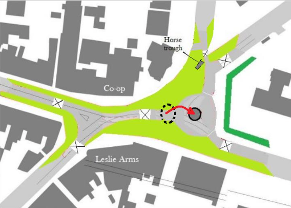
- The possible layout demonstrated below pulls the Morland / Lower Addiscombe Road corner further east, allowing its separation from the entrance from Cherry Orchard Road.
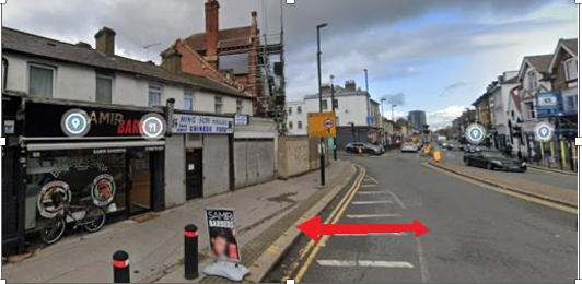
- By widening the pavement in front of Samir’s Barber a kink is formed in Lower Addiscombe Road that would act as traffic calmer by breaking up the continuous view of the long straight road ( as well as enhance the greened effect).
- The corner on the west side of the junction (from Cherry Orchard Road left onto Lower Addiscombe Road) has been widened. This would allow a left turn at that junction, instead of cars and buses having to go the extra distance around the roundabout. The roundabout is apparently there due to the no-left-turn for the buses, so if this were done it might allow complete removal of the roundabout.
- All options have widened pavements and allow for trees and bike lanes.
- Positioning of pedestrian crossings needs careful thought to allow the joining up of the various sides of the junction and to stop kids jumping over the fences to cross the dangerous roads while still allowing a good flow of traffic.
- The option gives more space in front of the Leslie Arms, currently a dangerously narrow pavement.
- A picture of a modern flat type of roundabout has been included below that should be considered if the roundabout must stay.
- It should be noted that the wide bends and generous roads are not required for cars travelling within the speed limit, especially if reduced to 20mph. Tighter curves and bends would help control speeds and calm traffic. Reduction of the speed limit to 20mph has (counter intuitively) been shown to increase flow levels at junctions like this.
The Leslie Arms Junction as it is now with much of the area taken up by road and traffic islands. Very thin pavements are a problem on all sides of the junction.
A revised layout with the roundabout moved east by ten meters taking over the planter area. The roundabout is also reduced slightly in size. This allows for a much larger area of public realm outside the doctor’s surgery and much wider pavements. Reclaimed public realm is the green area.
This option removes the roundabout completely, which allows through flow of traffic and gives even more opportunity for public realm space (shown in green).

This area could be made really welcoming with green areas, trees, wide pavements and a kiosk.
Mood Board
It would be possible to make this an amazing place for the local communities and visitors, as well as a welcoming gateway into central Croydon. The mood-board below gives an idea of the possible improvements to shop fronts and the changes that could be made to the roads and pavements. Many thanks to the architects Richard Mullins and Gita Deb for the drawings.

Flat roundabouts can be used with other low-cost road layouts to calm traffic down.

The grade II-listed Leslie Arms in better days. It has been included in the Victorian Society’s list of its top ten endangered buildings. Bringing it back for community use and as a center piece to the junction would be a massive success.

Next Steps
Whilst it is appreciated that surveys, feasibility and community engagement take time, we must not leave everything to be done in the long term. Some actions could start now!
Immediate action
- Ensure Section 106 funding from local developments is not lost away from the local area.
- Further community and shop/landlord engagement.
- Escalate within Croydon Council to generate interest and engagement.
- Link to the Healthy Streets initiative.
Short term
- Surveys (topo, traffic, lighting, pedestrian flow).
- Widening of pavement by Samir Barber shop.
- Enhance lighting (white instead of orange may be enough, but ideally add some).
- Reduce speed to 20mph through junction and roundabout.
- Look to enforce building standards on shops to ensure they are well kept externally.
- Tidy up raised bed area on the east of the junction, reducing height of tall weeds and plants to improve visibility.
- Add extra lighting to this hidden part of the junction.
- Take action to ensure that the hoarding around the Leslie Arms is renewed and set back to allow visibility from the crossing that it currently hides from oncoming cars. If possible, use this to widen the pavement around this dangerous curve.
- Consider removal of all or sections of the raised bed on the east of the junction to open up the view of this wide pavement and deter anti-social behavior.
- Remove vandalized unused telephone box on planter pavement.
- Plant another tree where one has died on planter pavement.
Medium term
- Junction layout option feasibility design.
- Improving shop fronts with a joined-up feel and make them more aesthetically welcoming.
- Add decorative/mood lighting to make the area more inviting when dark.
- Move zebra crossings to more useable positions.
- Use traffic calming measures to make safer for road and pavement users.
Longer term
- New road layout with replacement of the dangerous junction.
- Widen pavements and create additional urban realm with trees and planters etc.
- Removal of the roundabout if possible.
- Repositioning of the zebra crossings.
- Cycle path installation.
- Cycle parking.
- Drinking fountain.
- Short term car parking bays to help shopping.
- Associated signage.
- Power points for kiosk or pop-up stands
- Power for Christmas decorations.
- Large lettering to identify the junction.
