
On 27 February, Croydon Council planning committee endorsed the Croydon North End Quarter Masterplan Framework, prepared by Allies & Morrison on behalf of the developers Unibail-Rodamco-Westfield https://urwcroydon.com/masterplan-framework/?utm_source=substack&utm_medium=email. Allies & Morrison were previously responsible for the masterplan of the successful development north of Kings Cross station.
The Croydon North End Quarter Masterplan Framework proposes
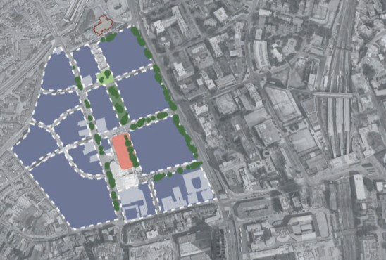
- opening up the area with pedestrian walkways. Apart from the existing North End, the main route could be from Drummond Road in the west to the east, ending at the entrance to Wellesley Road. Here a pedestrian crossing could continue the route via Lansdowne Road to read East Croydon station (at the foot of the pedestrian bridge over the railway).
- preserving and enhancing the settings of historic buildings, notably the Whitgift almshouses, Allders, buildings along North End, St Michael & All Angels and Electric House (currently housing London South Bank University)
- planting trees along the west side of Wellesley Road, the proposed east-west route and a new north-south route (Poplar Walk to George Street). The latter could form the eastern side of a public open space (in orange in the diagram above) and could also incorporate a linear park and a pocket park at its northern end.
- including several varied, fully accessible play areas
- concentrating retail premises in the existing Centrale shopping centre, North End and along the new east-west route.
- turning over much of the existing Whitgift Centre to housing, providing up to 3000 new units with each apartment block having its own private open space (sometimes above ground). At ground floor level, these buildings could accommodate leisure, sports, community, commercial, cultural, health, child care and education premises.
- residents would not have car parking facilities unless they have accessibility needs. However, public car parks could be provided for shoppers and other users of the facilities in the area.
The next step is for more detailed designs to be developed and applications for planning permission to be made. After that is granted, the site would be developed in a phased approach, to minimise disruption, over 10 to 15 years. Pop-up retail spaces, events and meanwhile uses could help businesses maintain trade during this period.
